Randonnée Marche Le Tholy - Cirkwi-Le_Trou_de_l_Enfer - Photo

Cirkwi-Le_Trou_de_l_Enfer

 Emmanuel Remy
Emmanuel Remy

Utilisateur

© OpenStreetMap contributors
Longueur
Longueur
13,4 km
Altitude max
Altitude max
788 m
Dénivelé positif
Dénivelé positif
438 m
Km-Effort
Km-Effort  
19,3 km
Altitude min
Altitude min
502 m
Dénivelé négatif
Dénivelé négatif
438 m
Boucle
Boucle
Oui
Date de création :
2023-10-12 10:26:30.617
Dernière modification :
2023-10-12 10:39:18.508

(0 Avis)

Marche
Marche
4h22
Difficulté : Très difficile

Scannez ce code QR pour ouvrir la randonnée dans l'application SityTrail

Application GPS de randonnée GRATUITE

Logo SityTrail SityTrail

IGN / Instituts géographiques

Télécharger SityTrail sur l'App Store Télécharger SityTrail sur Google Play

Logo SityTrail SityTrail World

Le monde est à vous

Télécharger SityTrail sur l'App Store Télécharger SityTrail sur Google Play Télécharger SityTrail sur Huawei AppGallery

À propos

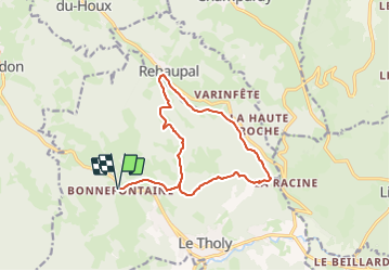
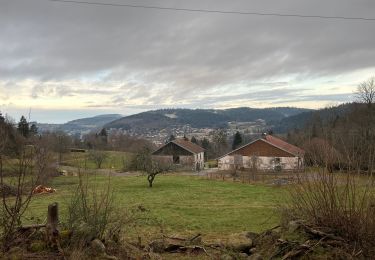
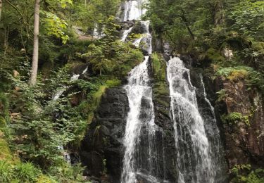
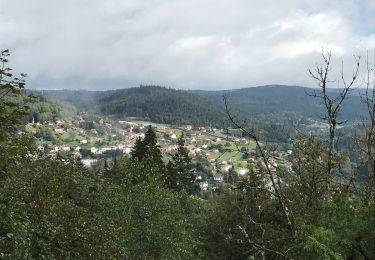
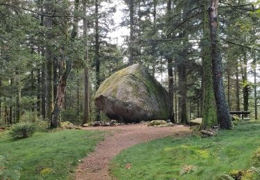
Randonnée Marche de 13,4 km à découvrir à Grand Est, Vosges, Le Tholy. Cette randonnée est proposée par Emmanuel Remy.

Description

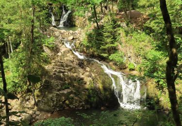
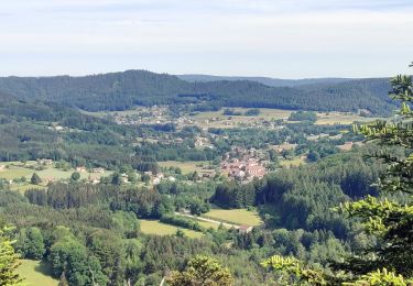
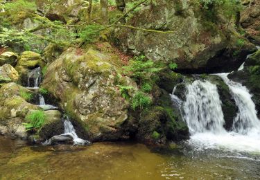
Tout au long de ce parcours sur des sentiers forestiers et ombragés, prenez le temps de découvrir les vestiges des siècles passés : moulin à farine, culture de lin en terrasse, canalisation du ruisseau, digues d’étang, etc.

Profil altimétrique

Points d'intérêt

Point d'intérêt Le Tholy -  - Photo
Emmanuel Remy
LE THOLY 
Point d'intérêt Le Tholy -  - Photo
Emmanuel Remy
LE THOLY 
Point d'intérêt Le Tholy -  - Photo
Emmanuel Remy
LE THOLY 
Point d'intérêt Le Tholy -  - Photo
Emmanuel Remy
LE THOLY 
Point d'intérêt Rehaupal -  - Photo
Emmanuel Remy
REHAUPAL 
Point d'intérêt Le Tholy -  - Photo
Emmanuel Remy
LE THOLY 
Point d'intérêt Le Tholy -  - Photo
Emmanuel Remy
LE THOLY 
Point d'intérêt Le Tholy -  - Photo
Emmanuel Remy
LE THOLY 
Point d'intérêt Le Tholy -  - Photo
Emmanuel Remy
LE THOLY 

Localisation

Pays :
France
Région :
Grand Est
Département/Province :
Vosges
Commune :
Le Tholy
Localité :
Unknown
Départ:(UTM)
330015 ; 5329381 (32U) N.

Randonnées à proximité

Randonnée Marche Tendon - Cascades de Tendon - Trou de l'Enfer - Roches de la Moulure - Photo
Marche
Bart2015

Marche

Moyen
(3)
Tendon, Grand Est, Vosges, France
20 km | 28 km-effort
5h 33min
Oui
Randonnée Randonnée équestre Le Tholy - 2022-06-03 Rando CVA Le Tholy Gerbamont - Photo
Randonnée équestre
GUIDE
holtzv

Randonnée équestre

Très difficile
Le Tholy, Grand Est, Vosges, France
28 km | 41 km-effort
6h 25min
Non
Randonnée Randonnée équestre Le Tholy - 2022-06-02 Rando CVA Le Tholy Tête des Cuveaux - Photo
Randonnée équestre
GUIDE
holtzv

Randonnée équestre

Difficile
Le Tholy, Grand Est, Vosges, France
28 km | 40 km-effort
5h 19min
Oui
Randonnée Randonnée équestre Le Tholy - 2022-06-01 Rando CVA Le Tholy Boucle Cascades du Tendon - Photo
Randonnée équestre
GUIDE
holtzv

Randonnée équestre

Difficile
Le Tholy, Grand Est, Vosges, France
24 km | 34 km-effort
5h 16min
Oui
Randonnée Marche Le Tholy - tendon  - Photo
Marche
michelelfn

Marche

Facile
(4)
Le Tholy, Grand Est, Vosges, France
9,1 km | 12,9 km-effort
3h 1min
Oui
Randonnée Marche Le Tholy - La grande cascade du Tendon au départ du Grand Caillou. - Photo
Marche
FouargePatrick

Marche

Difficile
Le Tholy, Grand Est, Vosges, France
9 km | 12,2 km-effort
2h 46min
Oui
Randonnée Marche La Forge - La roche des corbeaux, La Forge  - Photo
Marche
FouargePatrick

Marche

Moyen
La Forge, Grand Est, Vosges, France
7,8 km | 11,2 km-effort
2h 33min
Oui
Randonnée Marche Le Tholy - Le trou de l'enfer - Photo
Marche
nana1643

Marche

Moyen
Le Tholy, Grand Est, Vosges, France
10,2 km | 14,2 km-effort
2h 48min
Oui
Randonnée Marche Cleurie - Circuit Cleurie / ST Amé - le Fossard - Photo
Marche
Emmanuel Remy

Marche

Facile
Cleurie, Grand Est, Vosges, France
14,1 km | 18,5 km-effort
3h 16min
Oui


Fermer
Mes abonnements